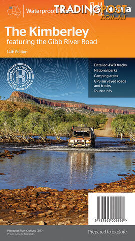
A regional map of the Kimberley that features the iconic Gibb River Road. On the reverse are inset maps for Purnululu...
DESCRIPTION
A regional map of the Kimberley that features the iconic Gibb River Road. On the reverse are inset maps for Purnululu National Park, the Dampier Peninsula and the Parry Creek area. There is also extensive drive detail and trip coverage for the Gibb River Road.
Waterproof paper Detailed 4WD tracks National parks Camping areas GPS surveyed roads & tracks
This new edition of Hemaâs best-selling Kimberley map features our latest mapping and points of interest in a stunning new cartographic style. It combines Hemaâs entire database of remote roads and 4WD tracks with touring points of interest and topographic information. This waterproof regional map of the Kimberley features the Gibb River Road. On the reverse are inset maps for Purnululu National Park, the Dampier Peninsula and the Parry Creek area. Detailed trip coverage and drive detail for the Gibb River Road is featured as well, with inset mapping covering the journey and corresponding text to guide explorers. Also included is national park information and relevant contact details for pre-trip planning and use on the road or track. Â Visit our website to view more similar products!
ADDITIONAL INFORMATION
Price
$14.95 (Sale)
Condition
New
YOU MAY ALSO LIKE
4
Whitevision LED Work Light 27W Flood Beam 9-30V 1800Lm SKU - LWL229F
WhiteVision Work Lamps The LWL200 LED Work Light Series provide capability with a solid design making them ideal for...


